Logging Summary
|
| IODP Expedition 306: |
|
North Atlantic Climate 2
Expedition 306
Scientific Party
|
| Introduction |
|
|
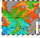
Figure
1. Map of Expedition 306
site locations in the North
Atlantic.
|
The primary objective of Expedition 306
was developing high-resolution late
Neogene–Quaternary climate proxy records
in the North Atlantic and putting these
into a PAC (Paleointensity Assisted
Chronology) framework. This PAC is
constructed from combination of
geomagnetic paleointensity, stable
isotope, and detrital layer
stratigraphies. Sites drilled during
Expedition 306 are located north of the
Azores near the Mid-Atlantic Ridge
(Sites U1312 and U1313 (reoccupation of
ODP Sites 608 and 607, respectively), on
the middle of the Gardar Drift (Site
U1314), and a CORK emplacement at Site
U1315 with associated downhole logging
at nearby ODP Hole 642E (Figure 1).
Several possible locations for drilling
on Eirik Drift in Labrador Sea had to be
abandoned due to poor weather.
The primary logging objectives of
Expedition 306 were Sites U1313 and one
of 2 Eirik Drift sites. The goal at the
two sites was to provide corrected
depth-scale information from core-log
integration to account for core
expansion and overall quality control of
the spliced record. Due to high
sedimentation rates at most of the
Expedition 306 sites, a secondary goal
was to look at millennial-scale changes
that would be identifiable in Formation
MircoScanner (FMS) data and
high-resolution Multi-sensor Gamma ray
tool (MGT) data. When the Eirik Drift
sites were abandoned, Site U1314 was
chosen but, again, due to poor weather,
no logging was possible.
|
|
Logging
Operations
|
Ultimately, only Site U1313 was logged
as part of Expedition 306. Downhole
logging operations were carried out
after completing coring of Hole U1313B
to a depth of 302 mbsf (3727 meters
below rig floor (mbrf)) and displaced
with sepiolite mud. The drill pipe was
raised to 65.3 mbsf (3489.6 mbrf) prior
to logging. During logging operations,
the sea state was fairly calm with a
typical heave of 2m or less. The initial
plan was to use two tool string
configurations, the triple combo” with
an additional Multi-sensor Gamma-ray
Tool (MGT) and the Formation Micro
Scanner (FMS)–sonic. However, shortly
after deploying the triple combo-MGT,
power problems forced us to bring the
tool string back on deck for
examination. It was determined that the
MGT tool was leaking and had caused
damage to the telemetry cartridge below.
The MGT was removed from the tool string
and a new telemetry cartridge was
installed on the tool string. Following
the repairs, the triple combo was
deployed successfully to the bottom of
the borehole at 300 mbsf (3725.3 mbrf).
This leak in the housing of the MGT
caused significant delays and there was
no time available for any additional
toolstrings.
As part of a CORK emplacement project
at Site U1315 that deployed a long term
(5 years) bottom water temperature
monitoring experiment, we did have the
unique opportunity to reoccupy and log
ODP 642E again after 20 years. The plan
was to use two tool string
configurations, the triple combination
(triple combo) with an additional
General Purpose Inclinometer Tool (GPIT)
and the FMS–sonic. The Lamont Borehole
Research Group’s (LDEO-BRG) Temperature,
Acceleration, and Pressure (TAP) tool
was deployed with triple combo and we
logged down slowly stopping every 5-10 m
over the upper 100 m and then logged
continuously at 1800 ft/hr down to total
depth of 588 mbsf. While collecting the
downhole temperature data, we also
logged down with the triple combo tool
string. At 588 mbsf, we reached an
impassable obstruction and stopped the
downhole logging. We then logged the
hole up into casing to a depth of 335
mbsf. After the triple combo, the
FMS-sonic tool string was also deployed
to ~580 mbsf after again reaching the
same hole obstruction as before. The
second pass of the FMS-Sonic was only
able to reach a total depth of ~440 mbsf
before reaching an obstruction. So, a
shortened second run was made from that
depth into casing until 310 mbsf.
Logging
Results
|
|
|
|
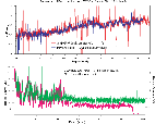
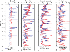
Figure 2.
Comparison of core and log
physical properties from Hole
U1313B. (A.) Bulk density for
the interval 80 to 300 mbsf.
(B.) Gamma ray radiation for the
interval 0 to 300 mbsf. cps =
counts per second; gAPI =
American Petroleum Institute
gamma ray units.
|
|
|
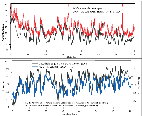
| Figure 3.
Detailed comparisons of core and
log physical properties from upper
70 mbsf of Hole U1313B. (A) Core
and log gamma-ray. (B) Core
“L”-(~CaCO3) and log gamma-ray. |
|
|
Figure 4.
Linear correlation of log
gamma-ray (interval 0-225 mbsf)
from Hole U1313B and benthic
oxygen isotope stack over last 5.4
Ma (Lisiecki and Raymo, 2005).
Both data sets are shown with
scales inverted so that warm
interglacials/low gamma-ray (ie
low Th =low clay) intervals are
shown as prominent peaks. The
correlation has only two tiepoints
at 0 and 5.2 Ma with no stretching
or squeezing of log data depths.
|
Logging Highlights: Hole U1313B
The successful deployment of the triple
combo tool string at U1313B provided
complete coverage of the 300m section
and provided very good physical property
and lithologic information for density,
porosity, natural gamma-ray, resistivity
and photoelectric effect. Corresponding
core physical property measurements were
very consistent with in situ downhole
data (Figure 2).
Due to the high detrital content of the
core, we were able to use the downhole
natural gamma measurements recorded
through the cased portion of the hole
(0-70 mbsf) for detailed stratigraphic
correlation (Figure
3). While the signal was
attenuated by 4-5X, the correlation was
critical for correlation in this
critical Quaternary section at this
locations. Also of special note is the
dramatically consistent linear
correlation of downhole natural
gamma-ray (upper 225 mbsf) with the
recent Lisiecki and Raymo (2005) benthic
oxygen isotope record over the last 5.4
Ma (Figure 4).
The consistency of downhole data with
both core data and age models will allow
mapping of spliced core record to actual
depth resulting in more accurate
sedimentation rate calculations as well
as more detailed age/depth models.
|
|
|
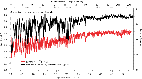
Figure
5. Comparison of old and
new physical properties from
Hole 642E.
Caliper (in), Porosity (%),
Gamma-ray and Thorium (gAPI =
American Petroleum Institute
gamma ray units). All new data
is shown in blue and old data in
red.
|
|
|
|
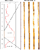
Figure 6.
Detailed resistivity profile
over an interval from 530 to 550
mbsf at Hole 642E showing a
pattern of basalt flows with
lower resistivity at the top and
increasing towards the bottom.
An enlarged portion of a FMS
image showing volcaniclastic
(basaltic vitric tuff) interval
beneath one flow and at the top
of the next between 546 to 548
mbsf.
|
|
|
|
Figure 7.
Detailed resistivity profile
over an interval from 530 to 550
mbsf at Hole 642E showing the
pattern of basalt flows with a
lower resistivity at the top and
increasing towards the bottom. A
blowup of a FMS image showing
fine-grained basalt interval
between 542 to 545 mbsf.
|
Logging highlights: Hole 642E
A) Log(New)-Log(Old) Comparisons
An important part of re-visiting this
ODP legacy site is an evaluation of hole
conditions after 20 years. The rotary
bit size used for coring this site was
9.75 in. The original caliper log is
plotted against 2 calipers from the FMS
tool (Figure 5).
As can be seen, the original caliper
(density tool) was not very reliable
showing a much larger than bit size hole
for almost the entire length of the
cored interval. Most of the intervals
with hole sizes larger than 12 in the
new FMS caliper logs correspond to high
porosity-low resistivity zones.
A comparison of porosity logs shows a
very good correlation downhole. The
overall variability of porosity is much
larger (10 to 95%) than the original
measurements (15 to 70%)(Figure 5)
and is attributed to a perhaps more
sensitive porosity sonde.
Measured total gamma-ray data from the old
and new logs at 642E are generally close
overall. Density logs (not shown) from
both studies also appear to be reliable
between the two data sets with most values
ranging between 2 and 3 g/cm3.
B) FMS/Sonic Logging
FMS imaging of the hole yielded good
results and will allow easy correlation
to existing core data and filling in the
gaps (~60% of the formation). Examples
from the volcaniclastic and fine-grained
basalt intervals are shown in Figures 6
and 7,
respectively.
The fine-scale (cm) resistivity data
will allow high-resolution studies of
fracture density of basalts and porosity
within the sequence. Combined with new
shear wave data from the Sonic tool, it
should be possible to construct more
reliable permeability estimates as well
as revised synthetic seismograms that
may yield better depth-velocity
correlations.
C) Temperature Log at
ODP Hole 642E
|
|
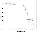
| Figure 8.
Temperature log profile versus
depth at Hole 642E collected using
TAP tool. |
A temperature log (Figure 8)
was obtained at Hole 642E using the
L-DEO-BRG TAP tool. This tool logs at a
rate of 1 Hz, has a precision of 5 mK
and an accuracy of 1 K. The temperature
was logged on the way down. The TAP tool
was held off bottom for a few minutes
and indicates a bottom water temperature
of approximately 0.2° C. The 10 m of the
borehole has a very steep gradient
(~2500 °C/km). Below this section the
borehole has a relatively low gradient
of approximately 22° C/km. The borehole
is cased to a depth 390 mbsf. At a depth
of approximately 500 mbsf a positive
temperature excursion may indicate
inflow. The temperature log as a whole
indicates significant fluid discharge
that may be as much as 10’s of meters
per year. This excursion may correlate
with a high permeability zone indicated
in the other logs.
|
Sean Higgins : Logging Staff
Scientist, Borehole Research Group,
Lamont-Doherty Earth Observatory of
Columbia University, PO Box 1000, 61
Route 9W, Palisades NY 10964, USA
|
|
|